Key Takeaways
- Leave before you think you need to — in Paradise, some residents had 15 minutes; in Lahaina, many had zero warning.
- Create and maintain 100 feet of defensible space around your home using the three-zone system; it's the single most effective action against structure loss.
- Harden your home against ember intrusion starting with attic vents and gutters — embers ignite roughly 90% of wildfire-destroyed homes, not direct flames.
- Pre-plan and physically drive at least three evacuation routes before fire season; single-road bottlenecks killed people in both Paradise and Lahaina.
- Layer multiple alert systems now and never rely on a single warning channel — in Lahaina, the siren system was never activated.
As a Wilderness First Responder who’s worked wildfire evacuation support during multiple Oregon fire seasons, I’ve seen what happens when communities treat fire season as background noise. During the 2020 Labor Day fires that burned over a million acres across Oregon and forced mass evacuations through the Willamette Valley, I watched families sprint from their homes with nothing but the clothes on their backs. The wildfire preparedness guidance in this article comes from real deployments and hard-earned field experience — not textbooks. The conditions that destroyed Paradise, California exist in hundreds of communities across the Pacific Northwest right now. Here’s how to be ready.
Quick Summary
- The Camp Fire gave some residents 15 minutes to evacuate. Lahaina residents got zero warning. Leave before you’re told to.
- Embers — not direct flames — ignite roughly 90% of homes destroyed in wildland-urban interface fires. Screening attic vents and cleaning gutters are your highest-impact, lowest-cost retrofits.
- 100 feet of defensible space around your home is the single most effective action to prevent structure loss, and it can directly affect your insurance eligibility.
- Pre-drive at least three evacuation routes before fire season. Single-road bottlenecks killed people in both Paradise and Lahaina.
- Layer multiple alert systems — county apps, WEA, Zonehaven, social media — because no single channel is reliable during a fast-moving fire.
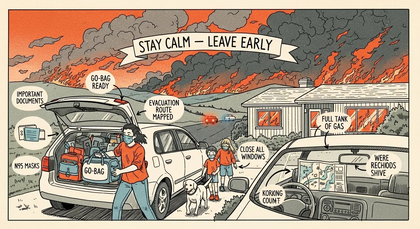
- Stage wildfire go-bags at your front door with 72 hours of supplies, N95 masks, critical documents, and medications for every household member.
What Caused the 2018 Camp Fire — And Why It Should Change How You Prepare
On the morning of November 8, 2018, a worn C-hook on PG&E’s Caribou-Palermo transmission line failed near the community of Pulga in Butte County, California. That component — a small piece of hardware holding a high-voltage line — had been in service for nearly a century. When it broke, the energized line hit the steel tower and threw sparks into tinder-dry brush. Humidity was in the single digits. Jarbo winds — the local name for the Diablo winds that rip through the Feather River Canyon — were gusting over 50 mph.
The fire found fuel and wind, and it exploded. By 6:30 AM, roughly 15 minutes after ignition, the Camp Fire had already outrun initial containment capability. It jumped the Feather River Canyon and raced southwest through Concow and into Paradise, covering roughly 80 football fields per minute. By 8:00 AM, the fire was in Paradise. By noon, the town was largely destroyed.
PG&E subsequently pleaded guilty to 84 counts of involuntary manslaughter and filed for bankruptcy. The Camp Fire became the deadliest and most destructive wildfire in California history.
Here’s why this matters to you directly: the Camp Fire wasn’t caused by an unpredictable act of nature. It was caused by a predictable infrastructure failure in a known fire-prone area during forecasted high-wind conditions. CAL FIRE’s after-action report documented years of deferred maintenance on the very transmission line that started the fire. This isn’t an anomaly — it’s a failure mode that exists in every community sitting in the wildland-urban interface with overhead power lines and aging infrastructure.
If you live in a fire-prone area, the cause of the Camp Fire should change three things about how you think: where you choose to live, how aggressively you prepare, and how early you decide to evacuate.
How Much Warning You’ll Actually Get
Here’s the uncomfortable truth about wildfire preparedness: your warning time can range from several days to literally minutes, and you won’t know which you’re getting until it’s too late. In ideal conditions — a fire starts miles away, wind is manageable, authorities have good situational awareness — you might get an evacuation warning 24-48 hours before a mandatory order. That’s the optimistic scenario. In the Camp Fire, some neighborhoods got 15 minutes. In Lahaina, many people got zero.
Understanding your alert systems — and their limitations — is critical:
- Wireless Emergency Alerts (WEA): The blaring alerts that hit your phone during emergencies. They’re part of FEMA’s Integrated Public Alert and Warning System (IPAWS) and are opt-out on most phones. But WEA alerts are geographically broad, sometimes delayed, and can’t replace local systems.
- County-level systems: Services like CodeRED, Everbridge, or Rave Alert are used by most counties for targeted evacuation warnings and orders. These require you to opt in and register — they won’t find you automatically. Google your county’s emergency notification system and sign up today.
- Community zone tools: Platforms like Zonehaven and Genasys provide real-time evacuation zone status maps showing whether your specific neighborhood is under warning, order, or all-clear. Bookmark your local version now.
- Social media and scanner apps: During fast-moving fires, local fire departments and sheriff’s offices often post updates on social media faster than official alert systems can process them.
An evacuation warning means “be ready to leave.” An evacuation order means “leave now.” In my experience working fire seasons in Oregon, I recommend treating warnings as orders whenever high winds are in the forecast. By the time a warning gets upgraded in wind-driven conditions, roads may already be jammed.
For a complete approach to coordinating with your household during emergencies, I recommend building a family emergency communication plan before fire season starts. Redundancy saves lives — don’t rely on a single channel to tell you when to go.
So how fast does a wildfire actually move? Fire in brush and grass can travel at 6 mph or faster. That’s a brisk jog, and it doesn’t get tired. Wind-driven fire can hit 14+ mph, and in extreme cases like Paradise, the fire covered ground at the equivalent of freeway speed. The signals that precede wildfire aren’t subtle if you’re paying attention: extended drought, low humidity, high winds, red flag warnings from the National Weather Service. But the specific moment of ignition? Unpredictable. The difference between people who survive and people who don’t often comes down to one decision: leaving before they’re told to.
Wildfire Preparedness Checklist: 10 Essential Steps
- Stage wildfire go-bags at your front door with 72 hours of supplies for every person
- Create 100 feet of defensible space by clearing vegetation in zones around your home
- Harden your home against embers with fire-rated roofing, screened vents, and clean gutters
- Pre-plan three evacuation routes and physically drive each one before fire season
- Register for all emergency alert systems including county, state, and federal channels
- Keep vehicle fuel above half at all times during fire season — no exceptions
- Stock N95 masks for every family member in go-bags, vehicles, and at work
- Photograph every room for insurance documentation and store images in the cloud
- Keep a physical documents folder with IDs, insurance policies, and medical records ready
- Practice evacuation drills with your household so everyone executes without hesitation
That checklist is your foundation. Everything below explains why each step matters and how to actually execute it.
How to Create Defensible Space: Zone-by-Zone Guide
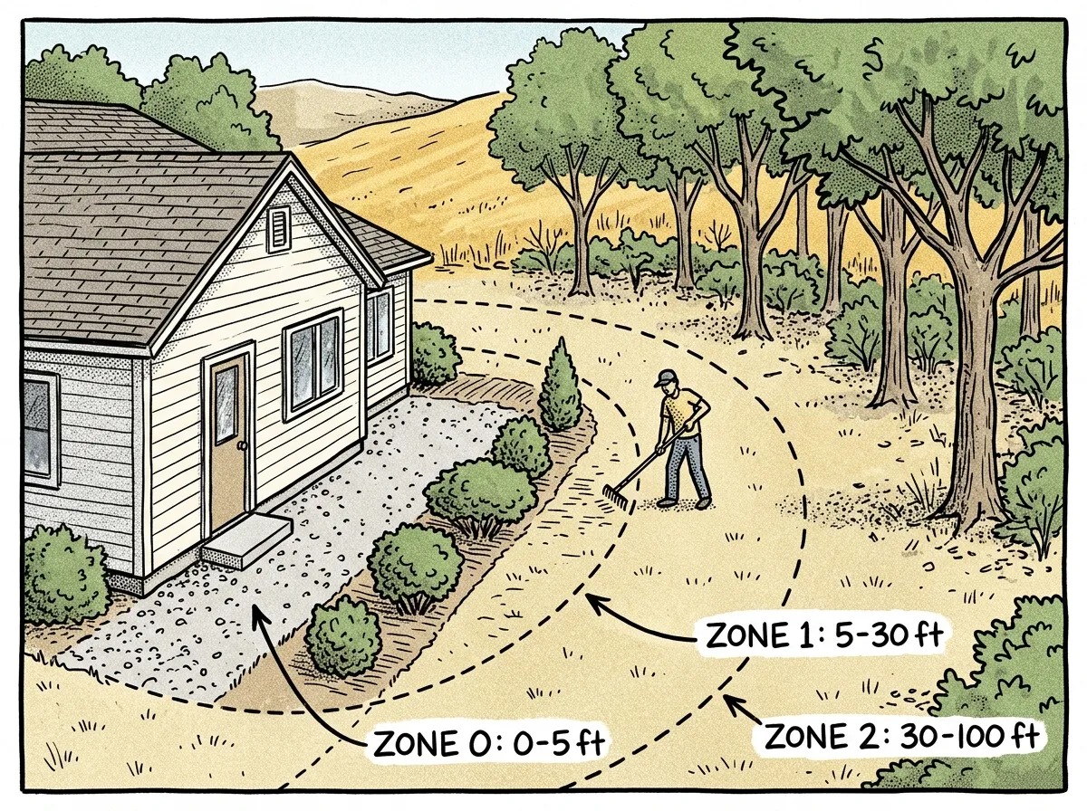 Three defensible space zones around a home, from ember-resistant to reduced fuel
Defensible space is the single most effective action you can take to prevent your home from burning during a wildfire. CAL FIRE’s PRC 4291 requires 100 feet of defensible space around structures in fire-prone areas, and compliance can directly affect your insurance eligibility. Even if you’re not in California, the science applies everywhere. The NFPA’s research consistently shows that homes with properly maintained defensible space are dramatically more likely to survive — even without firefighter intervention.
In my 12+ years of field work across Oregon and Washington, I’ve watched the wildland-urban interface expand into areas that were considered low-risk a decade ago. Here’s how to break it down:
Zone 0: The Ember-Resistant Zone (0-5 Feet)
This is the most critical zone and the one most people neglect. Within five feet of your house, you want nothing that burns. Period.
- Replace mulch with gravel, stone, or other non-combustible hardscaping
- Remove all dead vegetation, leaves, and pine needles
- Relocate firewood piles, propane tanks, and recycling bins
- Use non-combustible patio furniture or move combustible pieces away from the structure
- Ensure no tree branches overhang this zone
- Replace combustible fencing sections directly attached to the house with metal
Zone 1: Lean, Clean, and Green (5-30 Feet)
This zone should be irrigated, well-maintained landscaping with careful spacing to prevent fire from climbing into tree canopies.
- Keep grass mowed to 4 inches or less
- Remove all dead plants, dry leaves, and pine needles regularly
- Space trees so canopies are at least 10 feet apart
- Prune tree branches to at least 6-10 feet above the ground
- Choose fire-resistant plants: lavender, rockrose, ice plant, succulents, and hardwood deciduous trees
- Remove “ladder fuels” — shrubs and vegetation that can carry fire from ground level into tree canopies
Zone 2: Reduced Fuel Zone (30-100 Feet)
This zone doesn’t need to be manicured, but it does need to be managed to reduce fire intensity.
- Create horizontal spacing between shrubs and trees — at least 10 feet between shrub clusters
- Maintain vertical spacing by keeping the distance between grass, shrubs, and tree canopies separated
- Remove fallen branches, dead trees, and accumulated debris
- If you’re on a slope, increase all distances — fire travels faster uphill, so the downhill side of your property needs more clearance
Seasonal maintenance schedule: I do a major defensible space clearing in late spring before fire season, a midseason check in July, and a final cleanup after leaf fall in autumn. Set calendar reminders — this isn’t a one-time project.
I’ve seen people spend thousands on fire-resistant siding while their gutters are packed with pine needles and they’ve got a cord of firewood stacked against the house. That’s backwards. Zone 0 costs almost nothing — grab a rake, a wheelbarrow, and a bag of landscape gravel. Three weekends of honest work and you’ve done more to protect your home than any single expensive retrofit. Start at the house and work outward.
Wildfire-Proofing Your Home: Hardening Against Ember Intrusion
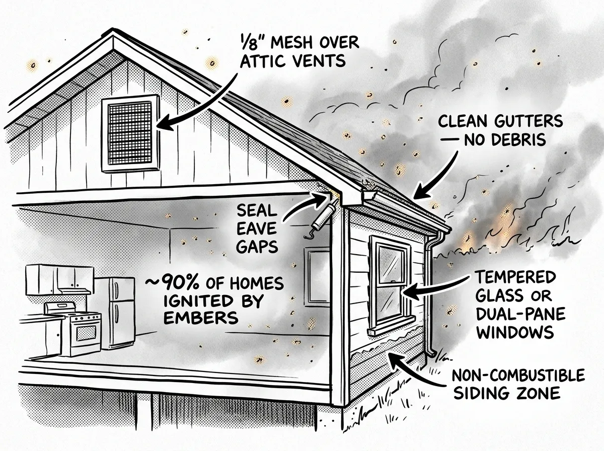 Key home-hardening retrofits to block ember intrusion at vulnerable entry points
Here’s a fact that surprises most people: according to the Insurance Institute for Business & Home Safety (IBHS), roughly 90% of homes destroyed in wildland-urban interface fires are ignited by embers, not direct flame contact. Burning debris carried by wind — sometimes from over a mile away — lands in gutters, on wood decks, and enters through attic vents. Your home can be fully engulfed before the fire front ever reaches your property.
Most homes don’t burn because fire reaches them. They burn because embers reach them first.
Understanding this changes your entire approach. Instead of trying to fireproof against a wall of flame (which is largely impossible for a residential structure), you’re plugging the specific entry points where embers infiltrate.
High Priority (Low to Moderate Cost):
- Attic and soffit vents: Replace standard mesh with 1/8-inch ember-resistant metal mesh. This is the single most cost-effective retrofit — embers entering attic spaces cause catastrophic ignition because attics are full of combustible insulation and framing.
- Gutters: Install metal gutter guards and clean gutters monthly during fire season. Accumulated leaves and pine needles in gutters are a perfect ember receptacle.
- The first 5 feet of fencing: If your wood fence connects directly to your house, replace those first five feet with metal fencing or a metal gate. I’ve seen fires follow a fence line straight to a home’s siding like a lit fuse.
Medium Priority (Moderate Cost):
- Decking: Replace wood decking within 10 feet of the structure with composite or non-combustible materials. At minimum, keep the area under and around your deck completely clear of debris.
- Eaves and soffits: Box in open eaves so embers can’t collect in the gap between the roof and exterior wall.
- Windows: Upgrade to dual-pane tempered glass. Single-pane windows can shatter from radiant heat alone, allowing embers inside.
Long-Term Investment (Higher Cost):
- Roofing: Ensure you have Class A fire-rated roofing (asphalt composition, metal, or tile). Wood shake roofs are essentially kindling. If you’ve got one, replacing it should be your top priority.
- Siding: Fiber cement or stucco siding dramatically outperforms vinyl or wood in ember exposure.
You don’t need to do everything at once. When I advise homeowners on a budget, I tell them to start with vent screens and gutter guards — those two retrofits alone address the highest-probability ignition scenarios and cost a few hundred dollars total.
Lessons from Paradise, Lahaina, and Australia’s Black Summer
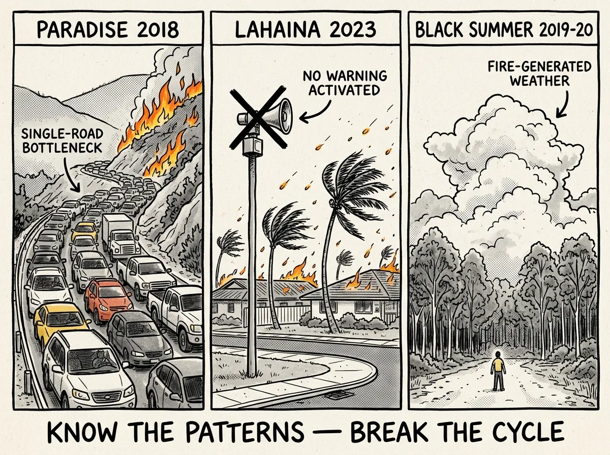 Common failure patterns from three catastrophic wildfire disasters
After studying these disasters — and working evacuation support during Oregon’s 2020 fire season — I’ve identified five failure patterns that repeat in every catastrophic wildfire. Each one has a specific action you can take right now.
1. Single-Road Evacuation Bottlenecks
Paradise had one main evacuation route: Skyway. Lahaina had essentially one road in each direction. When 27,000 people try to use the same two-lane road simultaneously, you get gridlock in a fire zone. People died in their cars.
Your action: Identify at least three evacuation routes from your home and physically drive each one. Include back roads, fire roads, and routes that don’t use main highways. If you need to brush up on navigating without GPS, basic orienteering and navigation skills are worth your time. Print paper maps — cell service may be down.
2. Failure or Delay of Warning Systems
In Lahaina, outdoor sirens were never activated. In the Camp Fire, notifications reached some neighborhoods only minutes before the fire. Alert systems failed or were too slow across all three disasters.
Your action: Register for every available alert system and never rely on a single channel. Monitor conditions yourself during red flag days. If you can smell smoke and winds are high, start your evacuation process without waiting for an official order.
3. Infrastructure-Caused Ignition
The Camp Fire was caused by a PG&E transmission line. Lahaina’s fire was linked to downed power lines. Australia’s fires included infrastructure-related ignitions. These aren’t freak accidents — they’re predictable failures in fire-prone areas with aging infrastructure.
Your action: Know the infrastructure risks in your area. If overhead power lines cross your property or neighborhood, factor that into your risk assessment and evacuation trigger points.
4. Underestimation of Wind-Driven Fire Speed
In every case, the fire moved faster than anyone predicted. Jarbo winds in Paradise. Hurricane-force winds in Lahaina. Variable winds during Black Summer. Authorities and residents consistently underestimated how quickly fire can travel in high-wind conditions.
Your action: During red flag warnings or high-wind events, treat any reported fire within 30 miles as a direct threat. Leave early. The math is simple: fire in grass moves at 6+ mph, wind-driven fire can reach 14+ mph, and in extreme cases the fire covers ground at freeway speed.
5. Inadequate Community-Level Pre-Planning
All three communities had incomplete or outdated evacuation plans. Traffic management broke down. Communication between agencies was fragmented.
Your action: Don’t depend on your community’s plan to save you. Build your own household plan with designated meeting points, communication protocols, and self-directed evacuation triggers. Know your family emergency communication plan cold.
The First 72 Hours After Evacuation
The first hour is about one thing: getting out alive. If a wildfire is approaching your area, your immediate priorities are people, pets, critical documents, and go-bags — in that order. You’re not saving the photo albums. You’re not loading furniture. You are leaving.
Before you walk out the door, execute this short list of actions that can save your home in your absence:
- Close every window and interior door — this slows ember penetration and limits oxygen flow
- Move flammable patio furniture, cushions, and doormats away from the structure
- Shut off propane tanks and natural gas at the meter if safe to do
- Connect garden hoses and leave them charged if time allows — arriving firefighters may use them
- Get everyone in the vehicle wearing N95 masks immediately
The first 24 hours after evacuation are chaotic and emotionally brutal. You’re in a shelter, a hotel, or on a friend’s couch, refreshing your phone obsessively for news. Cell towers may be down in the fire zone. You might not know if your home is standing. Your critical needs in this window are shelter, water, medications, and communication. If you’ve got a proper wildfire go-bag staged — something I walk through in detail in building a 72-hour emergency go-bag — this phase is uncomfortable but manageable. If you don’t, you’re standing in line at a Red Cross shelter hoping they have a spare toothbrush.
What Goes in Your Wildfire Go-Bag
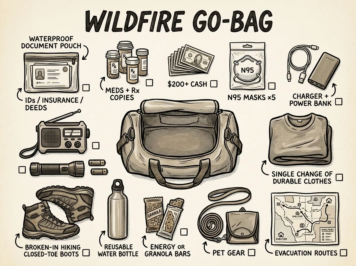 Complete wildfire go-bag contents laid out and ready to grab
- 1 gallon of water per person per day for 3 days
- 3-day supply of non-perishable food (energy bars, dried fruit, nuts)
- All current medications plus copies of prescriptions
- Critical documents in a waterproof bag: IDs, insurance policies, property deeds, medical records
- Phone chargers (battery bank and car charger)
- $200+ in small bills (ATMs lose power)
- N95 masks — at least 5 per person
- Flashlight with extra batteries
- Battery-powered or hand-crank NOAA weather radio
- Change of clothes and sturdy closed-toe shoes
Vehicle emergency kit additions for fire season: an ABC-rated fire extinguisher, a wool blanket (not synthetic — it melts), leather work gloves, a headlamp, and paper maps of your region.
One tip from my field experience: during fire season, keep a pair of sturdy shoes and long pants right beside your bed. Nighttime evacuations are disorienting, and I’ve seen people flee barefoot over embers and broken glass.
The Anker 737 PowerCore — around $110 — is what I keep in my go-bag. It’s got enough capacity to charge a phone four or five times, which matters when you’re displaced for days and cell towers are overloaded. I’ve watched people in shelters huddle around the one working outlet like it’s a campfire. A good battery bank eliminates that problem entirely. Don’t cheap out on this one — the $20 no-name brands lose capacity fast and some have concerning quality control.
Between 24 and 72 hours, the scope of the disaster becomes clearer. Ember casts — burning debris carried by wind — can ignite homes miles ahead of the main fire line, which means homes that appeared safe may still be at risk. Air quality will be hazardous across a wide area, sometimes hundreds of miles from the fire. Insurance companies start fielding calls they won’t return for weeks.
When Days Become Weeks
After the initial 72-hour survival phase, the grind begins. If your home survived, you may not be allowed back for days or weeks while authorities assess structural safety, downed power lines, and hazardous materials. If your home didn’t survive, you’re entering a months-to-years recovery process.
Temporary housing fills up fast. FEMA assistance takes weeks to process. The things you don’t think about start compounding: kids need school, prescriptions need refilling, commute routes may run through a closed fire zone. Water systems may be contaminated by benzene and other toxins from burned structures — after the Camp Fire, Paradise’s water system was contaminated for over a year.
Supply chains buckle. Gas stations run dry. Air quality may remain hazardous for weeks — California’s 2020 fire season blanketed the entire West Coast in smoke for over a month. This is the phase where having solid emergency camping gear for disaster displacement isn’t a luxury — it’s the difference between sleeping in your car and having a functional temporary setup with shelter, cooking capability, and water filtration.
Mental health deteriorates quickly here. The adrenaline of evacuation fades and is replaced by grief, frustration, and exhausting bureaucracy. Don’t underestimate this. It takes people down. FEMA’s crisis counseling program and the Disaster Distress Helpline (1-800-985-5990) are available after declared disasters.
Long-Term Wildfire Recovery: What to Expect
The long-term aftermath of a major wildfire reshapes communities in ways that aren’t obvious from the outside. Paradise lost roughly 90% of its structures in 2018. Five years later, the town had rebuilt only a fraction of its housing, and its population was still less than half of pre-fire levels. Many residents — especially renters, elderly people, and those without adequate insurance — never came back. The economic base collapsed: businesses closed, property tax revenue evaporated, and rebuilding with updated fire codes and doubled material costs priced out the middle class.
Lahaina faces similar long-term challenges, compounded by Maui’s already critical housing shortage and the cultural significance of what was lost.
For you personally, the long-term impact plays out in insurance battles, PTSD, and the slow realization that “home” as you knew it may not exist anymore. Wildfire zones are increasingly difficult and expensive to insure — major carriers have pulled out of high-risk areas in California entirely. If you live in a fire-prone region (and that region is expanding every year), wildfire preparedness isn’t a one-time project. It’s a permanent lifestyle adjustment. You maintain defensible space every year. You keep your go-bags current. You run evacuation drills with your family. You treat fire season the way coastal residents treat hurricane season — with respect, preparation, and a clear understanding that nature doesn’t negotiate.
If you’re starting from zero on your overall preparedness, the beginner’s guide to prepping essentials will help you build a solid foundation that applies across every type of disaster.
What Most People Get Wrong
The biggest mistake I see? Assuming you’ll have time. People picture a distant orange glow on the horizon, a calm phone call from authorities, and an orderly drive to a relative’s house. That’s not what happened in Paradise. That’s not what happened in Lahaina. What actually happens is this: you smell smoke, you check your phone, you see conflicting reports, you start to pack, the sky turns brown, embers begin falling on your roof, traffic stops moving, and now you’re running. The people who survived those disasters overwhelmingly had one thing in common — they left before they thought they needed to.
The second biggest mistake is believing your home is safe because it hasn’t burned before. Wildfire behavior isn’t static. Drought conditions, fuel loads, wind patterns, and the wildland-urban interface are all changing. Neighborhoods that were “safe” twenty years ago are in the red zone now. If you’re in a high desert area of eastern Oregon or the chaparral-heavy foothills of Southern California, the risk profile is completely different than it was a generation ago — and not in your favor.
People also chronically underestimate ember cast. They think fire destroys homes through direct flame contact, like a movie. In reality, most structure losses happen when burning debris enters through unscreened vents or lands in neglected gutters from fires that are still a mile or more away.
It’s 2 AM in late August. You wake up to the smell of smoke, step outside, and see an orange glow on the ridge three miles east. Your phone buzzes with an evacuation warning — not an order, just a warning. Wind is gusting hard. Do you wait for the official order, or do you grab your go-bag, load the dog, and leave now while the roads are empty? The families who survive this scenario are the ones who don’t wait.
And don’t discount wildfire smoke protection. Australia’s Black Summer killed more than ten times as many people from smoke inhalation as from direct fire exposure. A $2 N95 mask might be the most important piece of gear you own during fire season. Keep them everywhere — in your go-bag, your car, your desk at work. If you can smell smoke, you’re breathing particulate matter that damages your lungs, heart, and brain. Mask up immediately.
Take Action Before Fire Season
Wildfire preparedness isn’t something you can cram for the night before a fire shows up on the ridge. It’s built over weeks and months — maintaining defensible space, hardening your home, staging go-bags, registering for alerts, drilling your evacuation routes until they’re muscle memory. The families who survive catastrophic wildfire aren’t lucky. They’re prepared.
In my years as a FEMA-trained emergency management professional working in the Pacific Northwest, the single most consistent pattern I’ve observed is this: the people who act early survive. The people who wait for certainty run out of time. Start with the 10-step checklist above. Do one item today. Do another tomorrow. By the time fire season arrives, you won’t be standing in line at a Red Cross shelter wondering what happened. You’ll be the one who already had a plan.
This guide is reviewed and updated annually before fire season. Last reviewed: June 2026.
The Complete
Prepper's Reference.
149 articles synthesized into one comprehensive PDF — twelve chapters covering water, food, shelter, first aid, comms, and scenario-specific preparedness. Free with your email.
Unsubscribe anytime · We never share your email
You're in. Check your inbox.
Keep Reading
Lessons From Hurricane Katrina: Survival Guide
Key lessons from Hurricane Katrina that changed emergency preparedness forever. Practical survival strategies from a FEMA-trained Wilderness First Responder.
Earthquake Preparedness: Lessons from 1906 & 2011
Learn what the 1906 San Francisco and 2011 Japan earthquakes teach about earthquake preparedness. Complete checklist, survival tips, and expert guidance inside.
Volcanic Eruption Preparedness: When the Mountain Wakes Up
Mount St. Helens gave scientists 2 months of warning — yet 57 people still died. The 2022 Tonga eruption sent a shockwave around the planet twice. Here's what volcanic eruptions actually threaten, how far danger extends, and how to prepare whether you live near a volcano or not.